
Satellite Car Chase from Honest Directors on Vimeo.
sâmbătă, 27 februarie 2010
Car chase in Google Maps
For a little fun, watch this animated car chase short video which uses imagery pulled from Google Earth (the description of the video says Google Maps but clearly the opening zoom from the world down to the streets of Manhattan is pure Google Earth). The video was created by Honest which is the directing team of Jonathan Milott and Cary Murnion. The video is a very short (just over one minute) excursion through the busy streets of New York with periodic car crashes and tread marks burned into the pavement. Hope you like it! :)
joi, 18 februarie 2010
World’s Highest Resolution Pictures [ I ]
Angel Stadium in Anaheim, California.
Angel Stadium of Anaheim (originally Anaheim Stadium and later Edison International Field of Anaheim) is a modern-style ballpark located in Anaheim, California. It is the home ballpark to Major League Baseball's Los Angeles Angels of Anaheim of the American League, and was previously home to the NFL's Los Angeles Rams (now St. Louis Rams). The stadium is often referred to by its unofficial nickname The Big A.

Machu Picchu, Peru
Machu Picchu is a pre-Columbian Inca site located 2,430 metres (8,000 ft) above sea level. It is situated on a mountain ridge above the Urubamba Valley in Peru, which is 80 kilometres (50 mi) northwest of Cuzco and through which the Urubamba River flows. Most archaeologists believe that Machu Picchu was built as an estate for the Inca emperor Pachacuti (1438-1472). Often referred to as "The Lost City of the Incas", it is perhaps the most familiar icon of the Inca World. Collected September 8, 2003.
Angel Stadium of Anaheim (originally Anaheim Stadium and later Edison International Field of Anaheim) is a modern-style ballpark located in Anaheim, California. It is the home ballpark to Major League Baseball's Los Angeles Angels of Anaheim of the American League, and was previously home to the NFL's Los Angeles Rams (now St. Louis Rams). The stadium is often referred to by its unofficial nickname The Big A.
Machu Picchu, Peru
Machu Picchu is a pre-Columbian Inca site located 2,430 metres (8,000 ft) above sea level. It is situated on a mountain ridge above the Urubamba Valley in Peru, which is 80 kilometres (50 mi) northwest of Cuzco and through which the Urubamba River flows. Most archaeologists believe that Machu Picchu was built as an estate for the Inca emperor Pachacuti (1438-1472). Often referred to as "The Lost City of the Incas", it is perhaps the most familiar icon of the Inca World. Collected September 8, 2003.

Vancouver, British Columbia, Canada
This half-meter resolution image of Vancouver, British Columbia was collected by the GeoEye-1 satellite on April 26, 2009. The full image features the Olympic and Paralympic Village Vancouver, home to the athletes for the Vancouver 2010 Olympic games. The village is located on the southeast side of False Creek.

Bucharest State Circus Park & Dinamo Bucharest Stadium. Romania
This satellite image of Bucharest, Romania was taken from 423 miles in space by the GeoEye-1 satellite on Sept. 23, 2009. The image shows the Bucharest State Circus building and surrounding park. The State Circus building hosts local and touring circus troupes and can accommodate over 3,500 spectators.

This satellite image of Rome, Italy was taken from 423 miles in space by the GeoEye-1 satellite on Sept. 11, 2009. The image shows the Colosseum, which has 50,000 seats and was the largest amphitheatre ever built during the Roman Empire.

Dubai Airshow 2009, Airport Expo. Dubai, United Arab Emirates
This half-meter resolution satellite image of Dubai International Airport was taken from 423 miles in space by the GeoEye-1 satellite on Nov. 16, 2009 during the Dubai Airshow 2009. The airshow is the foremost aerospace event in the Middle East.

miercuri, 17 februarie 2010
Haiti Earthquake Free Maps and Related Resources
Maps, Web Maps, Open Source and related geospatial data and information related to the 2010 earthquake in Haiti
Haiti Earthquake GeoEye Satellite Maps on Google Earth - Working with satellite imaging company GeoEye, Google on Wednesday evening updated its imagery of Haiti to reflect the devastation of 12 Tuesday's earthquake.
Latest Worldwide Earthquakes List
or the
Latest USA Earthquakes List
ERDAS Apollo Web Service
DigitalGlobe - Haiti Coverage map (pdf)
or the
Latest USA Earthquakes List
ERDAS Apollo Web Service
DigitalGlobe - Haiti Coverage map (pdf)
The Advanced Spaceborne Thermal Emission and Reflection Radiometer (ASTER) instrument on NASA’s Terra spacecraft captured this false-color image of Haiti on January 21, 2010, nine days after a magnitude 7.0 earthquake struck the region and caused massive damage and loss of life, and one day after a large 5.9 aftershock caused additional damage.
While ASTER’s 15-meter (50-foot) resolution is not sufficient to see damaged buildings, it can be used to identify other results of the shaking. Tiny dots of white against the plant-covered landscape (red in this image) are possible landslides, a common occurrence in mountainous terrain after large earthquakes. The possible landslides were identified by carefully comparing the new image with an image acquired one year ago.
Port-au-Prince, Haiti’s capital, is silver in the false-color image. The rivers are pale blue, while the ocean is dark blue. Exposed soil is white. See the picture here
NASA 7.0 Quake Near Port Au Prince satellite image on January 21, 2010
National Geospatial-Intelligence Agency
We've worked closely with GeoEye throughout the afternoon to make their most recent satellite imagery of Haiti, taken at approximately 10:27am EST today, available as a KML overlay for Google Earth. You can download the KML here and open it in Google Earth, or look at it via the browser plug-in below. As you'll see, the imagery shows a powerful glimpse into the destruction in Haiti. Here are before-and-after screenshots of the Presidential Palace and an area of Port-au-Prince:

click to see full-size
We will continue to automatically update the layer (you'll only need to download it once) as we are able to make more imagery and data available.
New York Times - Relief map showing magnitude of the disaster
Earthquakes with 1,000 or more deaths since 1900
Earthquakes with 1,000 or more deaths since 1900
miercuri, 10 februarie 2010
New York - 1924-2008 - City Map Airphotos
CITY MAP - NEW YORK - AIRPHOTOS
History can be viewed in many ways, but man I’m I excited about this. I feel like I just found a time machine. NYC.gov has recently launched a Google-esque interactive aerial map of New York in 1924! I have now spent many hours obsessively traveling (virtually) all over the city to see how its changed. I’ve compiled some of my findings here to save everyone some time. Among other things you’ll see that the city was still sans airports in 1924, that there used to be another huge reservoir in Central Park, that the waterfront was much busier back then and that the city is much greener now than it used to be. This is a before and after history of New York City told by comparing aerial photography from 1924 and 2008. Much has changed in 84 years, and much has stayed the same. Here are some examples and observations.
All images are from NYC.gov. They were originally taken by Arthur S. Tuttle, Chief Engineer, Board of Estimate and Apportionment, who flew over the city in 1924 to document all of its landmarks.
You can navigate the map for yourself here
Click on the images below to enlarge.
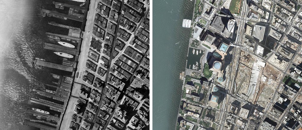
The original World Trade Center complex was built from 1966 -1973. Battery Park City, an addition to Manhattan’s west side, was built where piers used to stand using landfill from the WTC construction.
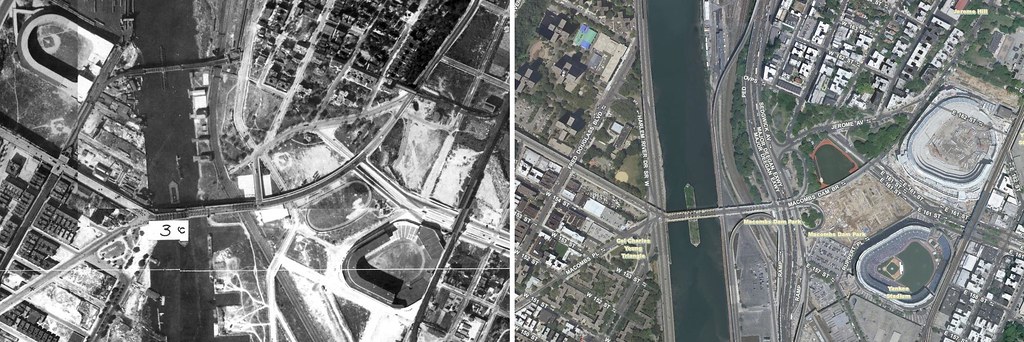
Yankee Stadium (lower right) was only one year old in 1924. The stadium seen at the upper left is the Polo Grounds, home to the New York Giants (now in San Francisco). The Polo Grounds originally opened in 1890 and had just been renovated in 1923. It was demolished in 1964.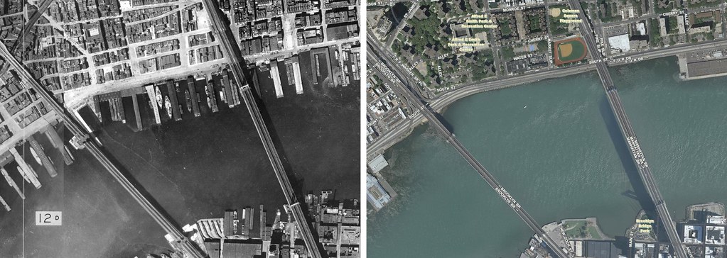
The waterfront around the Brooklyn and Manhattan Bridges was crowded with ships in 1924.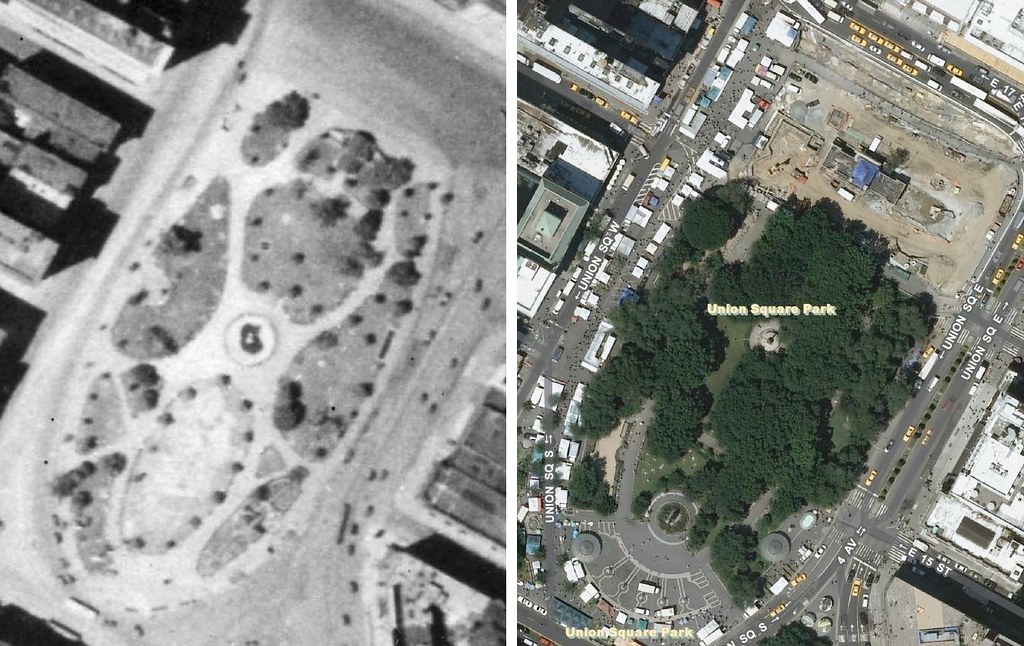
Union Square, one of the greatest public spaces in the world, was laid out in 1832 and rebuilt in 1882. It was looking pretty bare in 1924.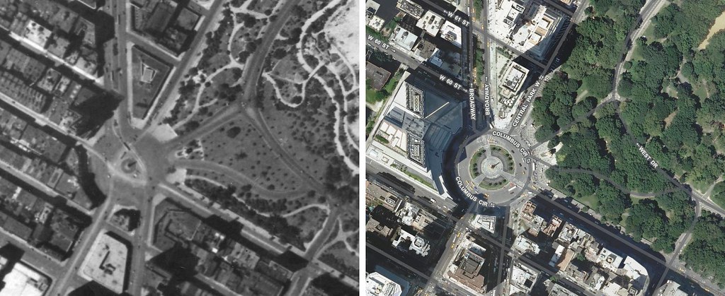
Columbus Circle has acquired more more circle-ness and vegetation.
The cathedral that was Penn Station was only 14 years old in 1924. It was demolished in 1963 and shoved underground to make way for Madison Square Garden.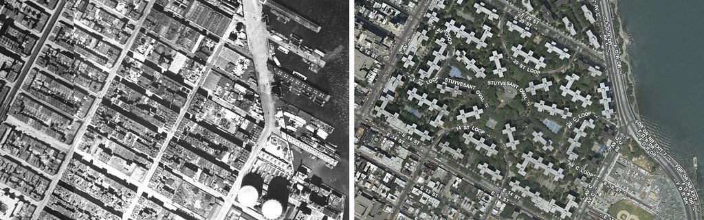
Stuyvesant Town was a Robert Moses era project built in the mid 1940s. Its of the most iconic and successful of post-war private housing communities and was occupied mostly by WWII veterans’ families.
From wikipedia:
Before the construction of Stuyvesant Town, the neighborhood contained eighteen typical city blocks, with public schools, churches, factories, private homes, apartments, small businesses, and even relatively new modern-style apartment buildings. In all, 600 buildings, containing 3,100 families, 500 stores and small factories, three churches, three schools, and two theaters, were razed. As would be repeated in later urban renewal projects, some 11,000 persons were forced to move from the neighborhood. In 1945, The New York Times called the move from the site "the greatest and most significant mass movement of families in New York’s history" (NYT, March 3, 1945). The last residents of the Gashouse District, the Delman Family, moved out in May 1946, allowing demolition to be soon concluded.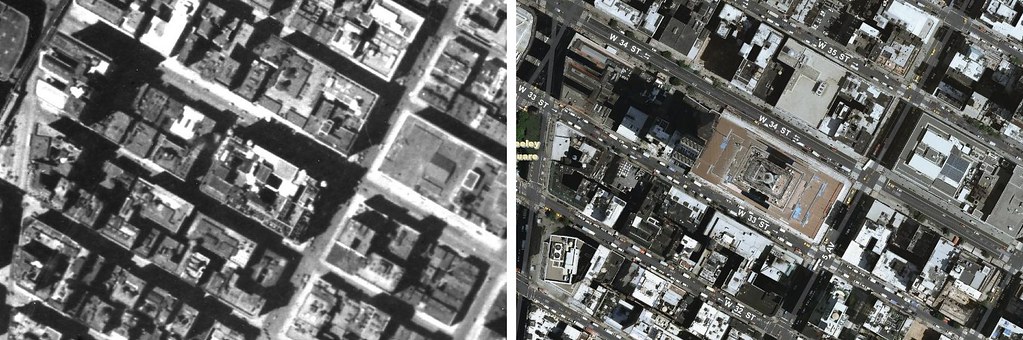
The Empire State Building was still 5 years away. Buildings were still standing on its future site in 1924.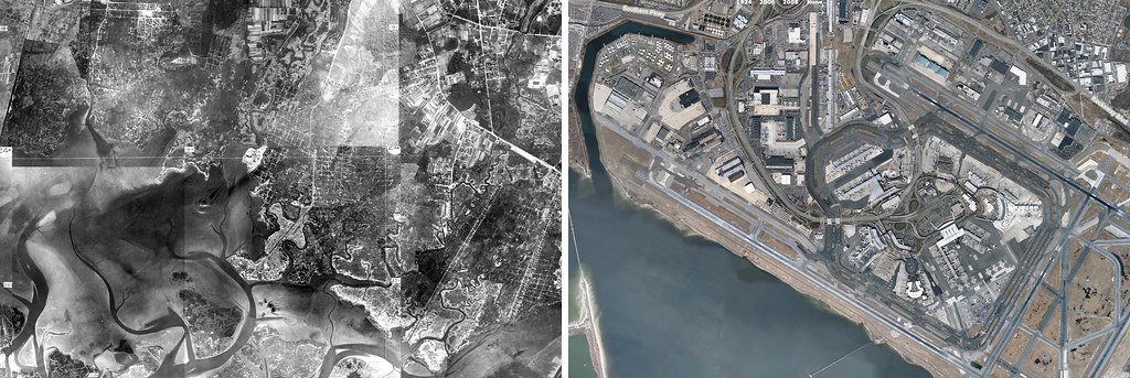
Built between 1943 and 1948 to relieve La Guardia’s traffic, JFK Airport was originally known as Idlewild after the Idlewild Golf Course it replaced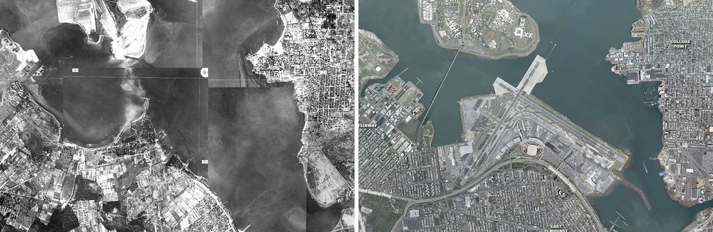
La Guardia Airport was built on fairgrounds previously used by the Gala Amusement Park. It originally opened as a private flying field named Glenn H. Curtiss Airport. It was later named North Beach Airport before being turned into a commercial airport and named New York Municipal Airport in 1939. It was renamed La Guardia, after the NYC mayor that championed it, in 1947.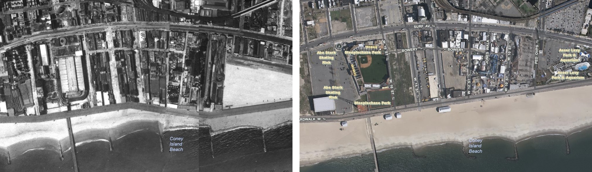
Coney Island picked up some new sand. The Cyclone roller coaster (on the right side of the 2008 picture, was built in 1927. There’s another roller coaster standing in its place in 1924. The iconic red Parachute Jump structure seen below the baseball stadium in the 2008 image, was not built until the 1939 New York World’s Fair.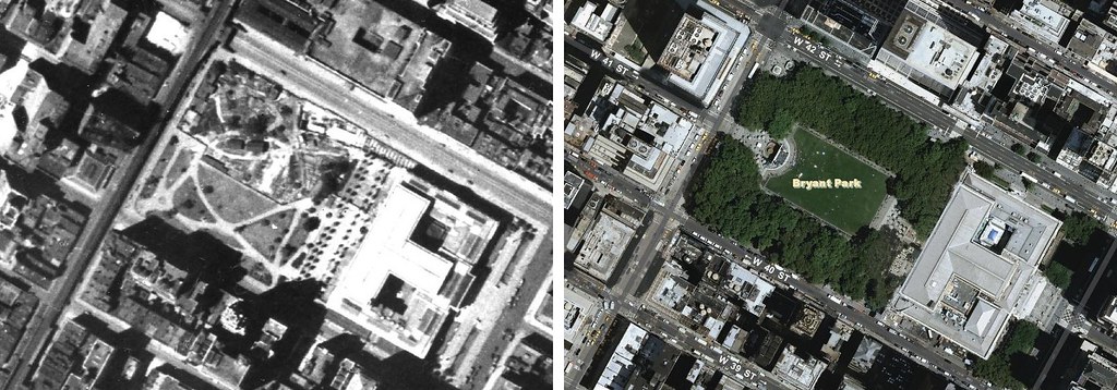
Bryant Park, originally built as Reservoir Square in 1847. The park has suffered many ups and downs throughout its history. In 1878, the new Sixth Avenue Elevated railway cast a shadow on the park, leading to neglect until the 1930s. It was redesigned in 1933 as a Great Depression public works project under Robert Moses, but again neglected after the El was taken down and construction began on the Sixth Ave Subway line. By the 70s, the park, the known as Needle Park was a haven for drug dealers, prostitutes and the homeless. The park was cleaned up through the 80s and redesigned completely in 1988. As you can see its looking a little better now then in 1924.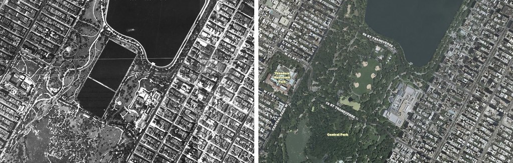
Central Park’s Great Lawn used to be a the Lower Reservoir. As the Croton-Catskill Reservoir system was completed, to satisfy New York City’s need for water, the Lower Reservoir came to be redundant. It started getting drained in 1930. It became a “Hooverville” of improvised shacks as it stood idle before being completed as the Great Lawn during La Guardia’s mayoral administration in 1936. The Metropolitan Museum, founded in 1870 and moved to its Central Park location in 1880, is the large structure seen in the park in the middle of the image.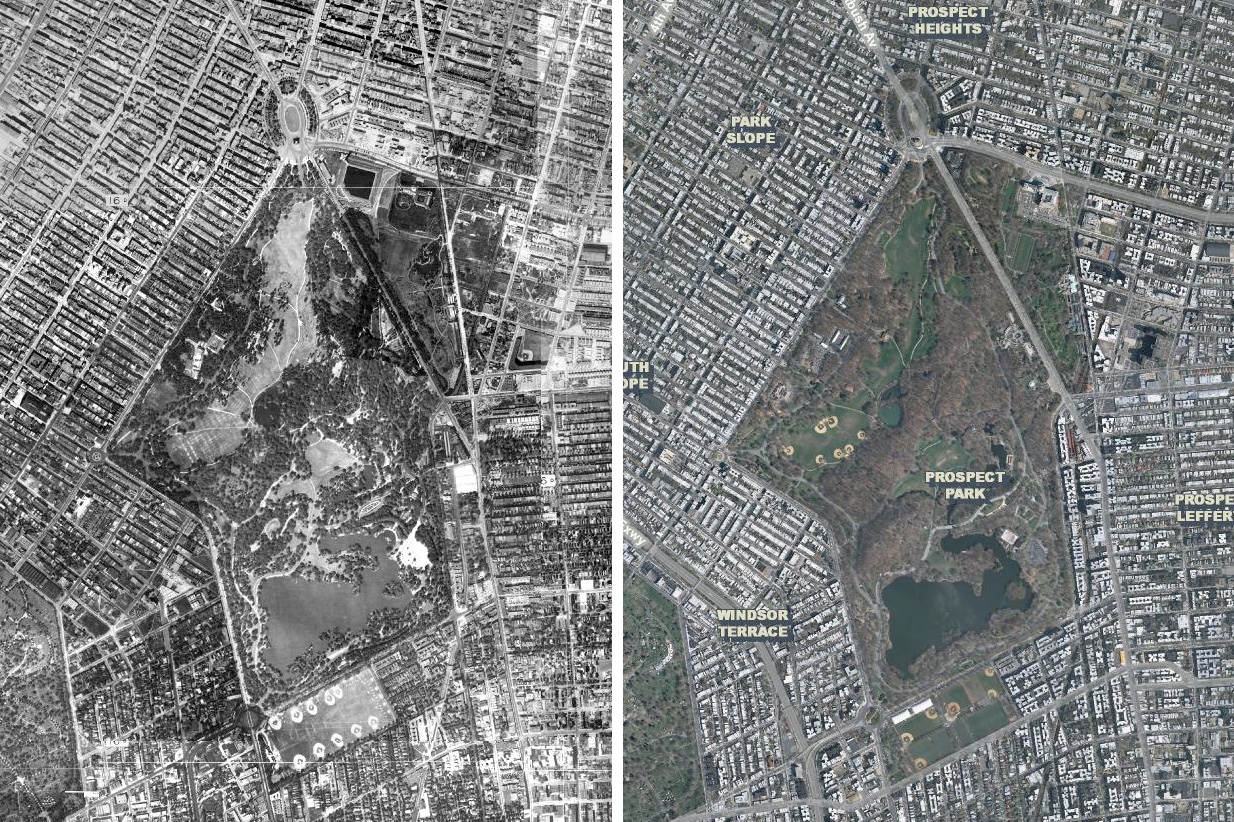
Prospect Park, designed by Frederick Law Olmsted and Calvert Vaux of Central Park (and many others) fame, opened in 1867. Its only 57 years old in this picture.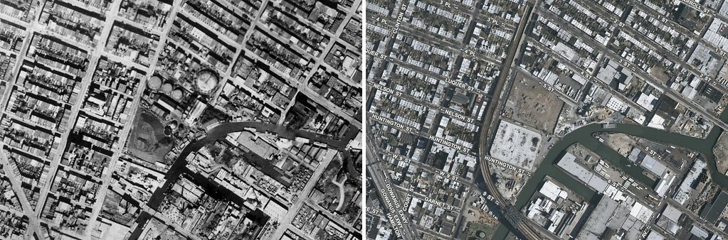
These are Hyperakt’s stomping grounds. The studio is located just a few blocks from the Gowanus Canal, a commercial waterway completed in 1869.
From wikipedia:
After World War I, with six million annual tons of cargo produced and trafficked though the waterway, the Gowanus Canal became the nation’s busiest commercial canal, and arguably the most polluted. The heavy sewage flow into the canal required regular dredging to keep the waters navigable.
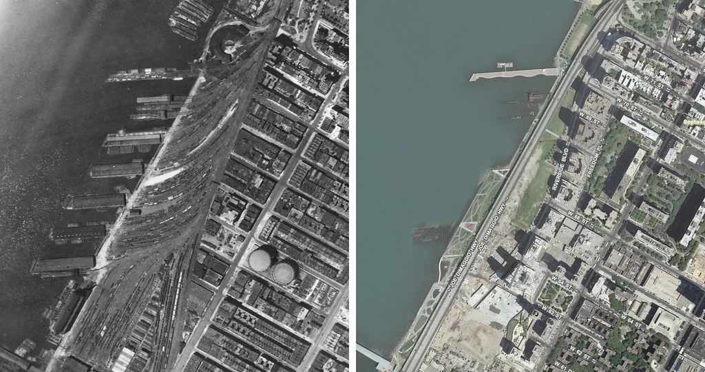
The west side rail yards in Manhattan.
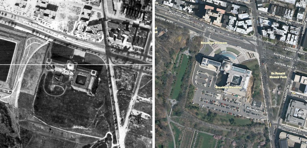
The Brooklyn Museum, designed by McKim, Mead, and White, opened its doors in 1897. The museum was originally intended to be about 4 times bigger, but funding for construction dried up.
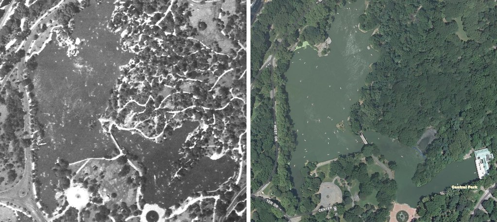
Some things haven’t changed much. The Central Park Lake has always been filled with boaters.
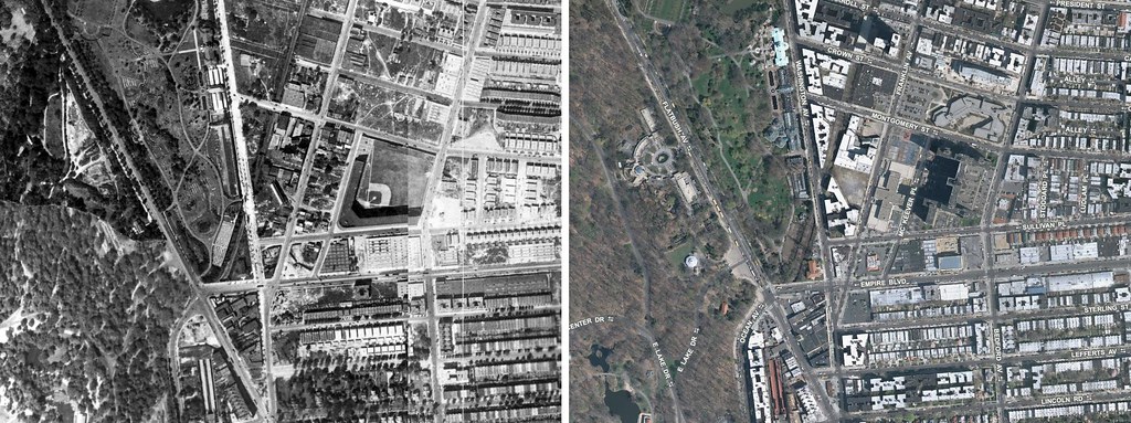
The Brooklyn Dodgers played at Ebbets Field, located just northeast of Prospect Park in Brooklyn. It opened in 1913 so it was just 11 years old here. The stadium was demolished in 1960 after the Dodgers moved to Los Angeles in 1957. It was replaced by a housing project.
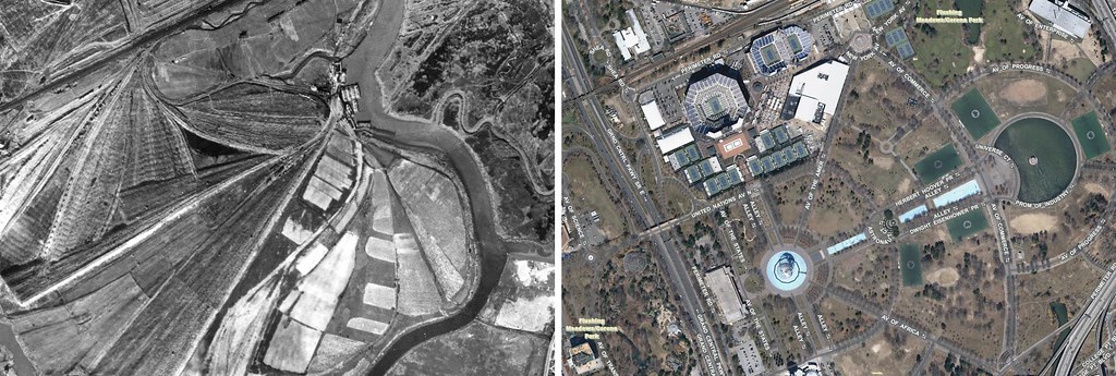
Flushing Meadows was another Robert Moses pet project. It was a massive dumping ground in 1924. It was developed in the 1930s to house the 1939/40 New York World’s Fair and later also housed the 1964/65 New York World’s Fair. The blue circle in the map on the right is the Unisphere, the centerpiece icon of the latter World’s Fair. The Unisphere is a 12-story high, spherical stainless steel representation of the Earth.
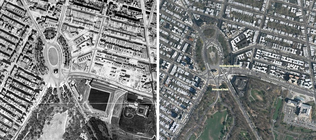
The glorious Grand Army Plaza is at the northwest corner of Prospect Park. It was designed by Frederick Law Olmsted and Calvert Vaux in 1867. Brooklyn had some serious Paris envy.

Central Park’s Sheep Meadow.
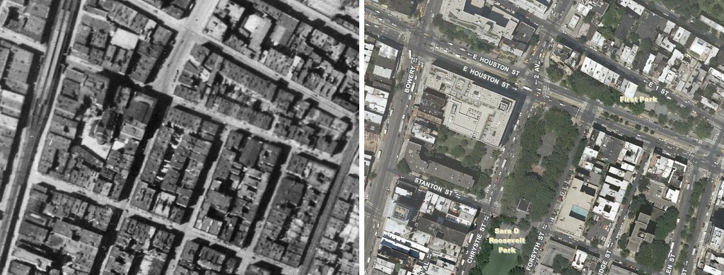
Sara Roosevelt Park at Houston and 2nd Ave was built in 1934, 10 years after this picture. Check out the elevated subway on the Bowery.
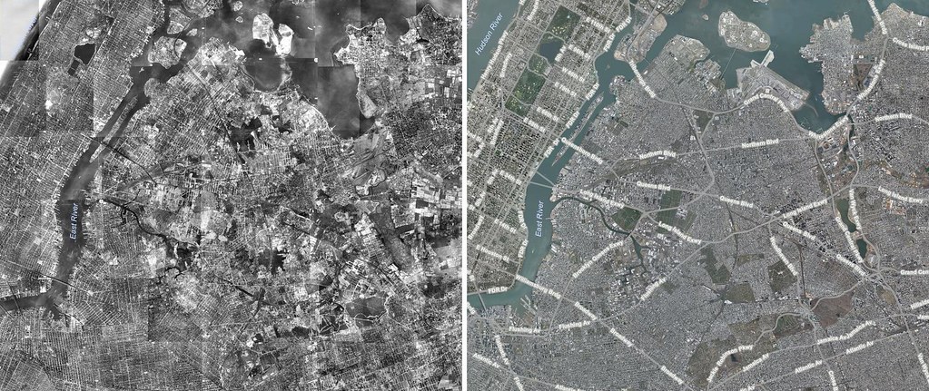
Manhattan, Brooklyn and Queens.
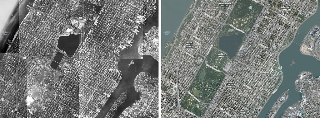
Central Park was opened in 1859, completed in 1873. The park was designed by the famous landscape architect Frederick Law Olmsted and the architect Calvert Vaux.
Abonați-vă la:
Comentarii (Atom)
